

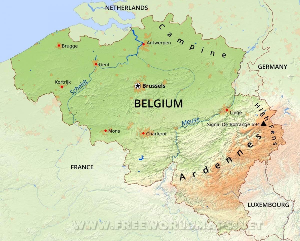
You can find on this page the Belgium geographical map to print and to download in PDF. The Belgium geographic map presents the topography, elevation, rivers, mountains, climate and physical features of Belgium in Western Europe.
The Belgium physical map shows landform and geography of Belgium. This geographical map of Belgium will allow you to discover physical features of Belgium in Western Europe. The Belgium physical map is downloadable in PDF, printable and free.
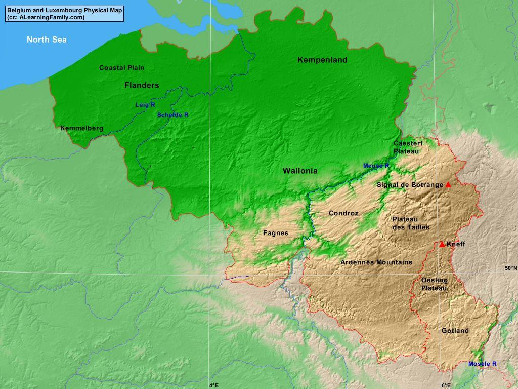
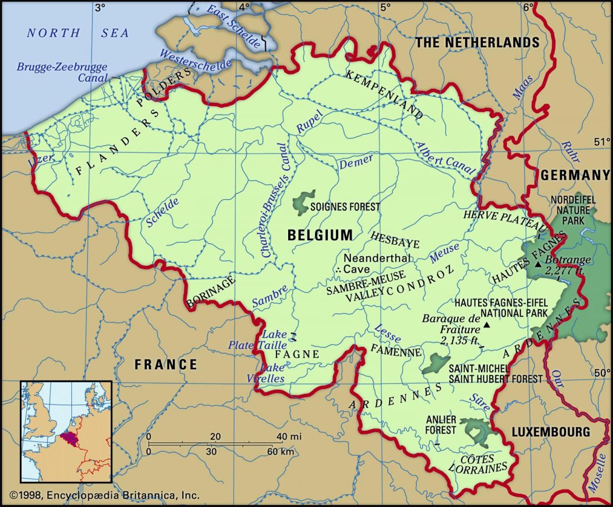
Belgium has three main geographical regions: the coastal plain in the north-west, the central plateau, and the Ardennes uplands in the south-east as you can see in Belgium physical map. The coastal plain is a flat low-lying area with hardly any expression of relief at the surface. Its subsurface, however, contains a rich archive of the depositional history that started about 10,000 years ago, and that represents the history of infill of a major pre-Holocene palaeovalley. The infill of the palaeovalley was controlled by several factors, among which relative sea level rise was initially the main driver. In the course of time, the balance between sediment supply and accommodation space took over the control of infill. Toward the end of the infill, humans played a prominent role in the further evolution of the plain, causing changes that ultimately determined its present-day characteristics.
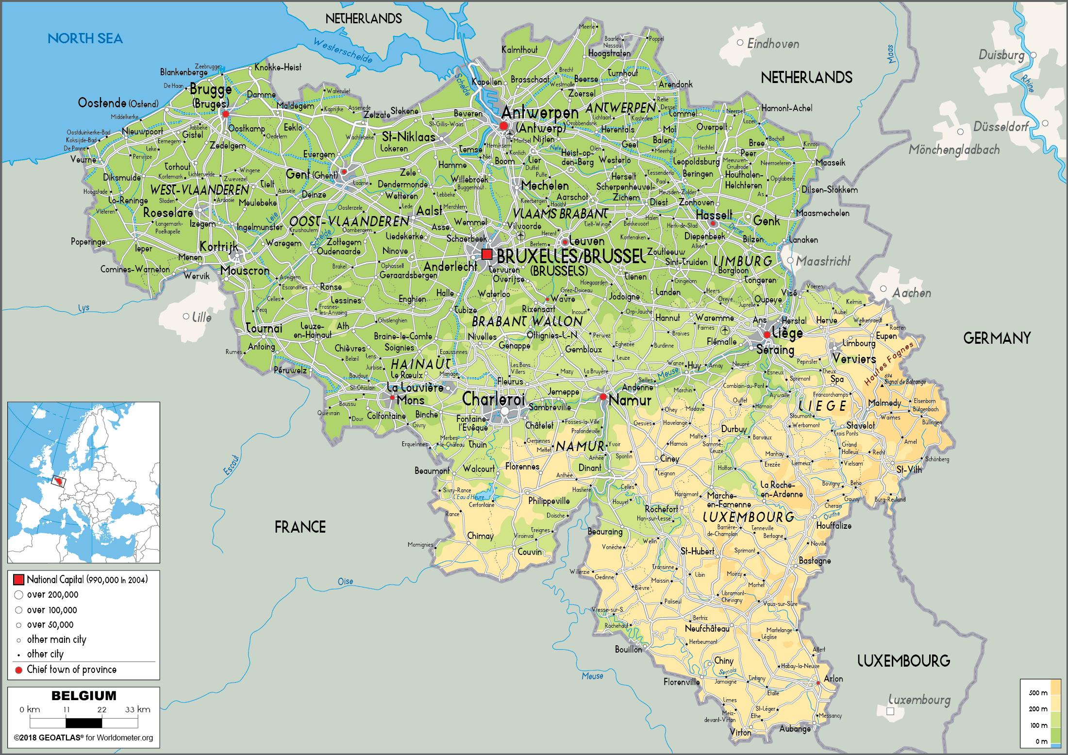
The second geographical region of Belgium, the central plateau, lies further inland as its shown in Belgium physical map. This is a smooth, slowly rising area that has many fertile valleys and is irrigated by many waterways. The central plateau of Belgium is a primarily smooth region with rolling hills and fertile valleys that are irrigated by rivers, canals, and dikes. Some higher land also exists here, with occasional wooded areas and some gorges and caves. Besides West Flanders and East Flanders, northern Belgium, which is generally referred to simply as Flanders, has three further provinces situated on the central plateau away from the coast. These are Antwerp, Limburg, and Brabant, which is now divided into Flemish Brabant and Walloon Brabant. In the center of Brabant province is the Brussels-Capital region, which surrounds and includes the city of Brussels.
Luxembourg province in southeastern Wallonia is principally a wooded plateau in the Ardennes, ranging from about 1,600 to 2,300 feet (500 to 700 meters) in elevation. It lies to the east and south of the River Meuse as its mentioned in Belgium physical map. The plateau is divided by rivers that flow in places through deep ravines and below craggy bluffs. Agriculture and cattle farming are chief occupations in this rural region. There is some heath land, and peat bogs are found in depressions in the landscape. The highest point in Belgium is the Signal de Botrange, which is only 2,277 feet (694 meters) above sea level, here in the mountains of the Ardennes. Luxembourg is the largest Belgian province but the most sparsely populated in a densely populated country. The provincial capital is Arlon. Tourism in this area is economically important; in recent years, many farmhouses and other buildings have been converted to provide tourist accommodations. Much of Belgium's remaining wildlife is found in this region.

Belgium topographic map shows the physical features of Belgium. This topographical map of Belgium will allow you to discover landforms and geographical of Belgium in Western Europe. The Belgium topographic map is downloadable in PDF, printable and free.
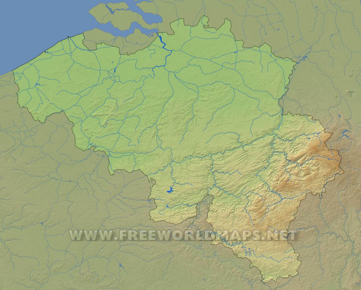
The principal topographic feature of Belgium is the Condroz, a plateau more than 1,100 feet (335 metres) in elevation comprising a succession of valleys hollowed out of the limestone between sandstone crests as you can see in Belgium topographic map. Its northern boundary is the Sambre-Meuse valley, which traverses Belgium from south-southwest to northeast. Situated south of the Ardennes and cut off from the rest of the country, Côtes Lorraines is a series of hills with north-facing scarps. About half of it remains wooded; in the south lies a small region of iron ore deposits.
A region of sand and clay soils lying between 150 and 650 feet (45 and 200 metres) in elevation, the Central Plateaus cover northern Hainaut, Walloon Brabant, southern Flemish Brabant, and the Hesbaye plateau region of Liège. The area is dissected by the Dender, Senne, Dijle, and other rivers that enter the Schelde (Escaut) River; it is bounded to the east by the Herve Plateau as its shown in Belgium topographic map. The Brussels region lies within the Central Plateaus. Bordering the North Sea from France to the Schelde is the low-lying plain of Flanders, which has two main sections. The rest of the country features a relatively flat topography consisting of coastal plains in the northwest and gently rolling hills throughout the country central portion.
Maritime Flanders, extending inland for about 5 to 10 miles (8 to 16 km), is a region of newly formed and reclaimed land (polders) protected by a line of dunes and dikes and having largely clay soils. Interior Flanders comprises most of East and West Flanders and has sand-silt or sand soils as its mentioned in Belgium topographic map. At an elevation of about 80 to 300 feet (25 to 90 metres), it is drained by the Leie, Schelde, and Dender rivers flowing northeastward to the Schelde estuary. Several shipping canals interlace the landscape and connect the river systems. Lying between about 160 and 330 feet (50 and 100 metres) in elevation, the Kempenland contains pastureland and is the site of a number of industrial enterprises; it forms an irregular watershed of plateau and plain between the extensive Schelde and Meuse drainage systems.
The Belgium elevation map shows the different altitudes of Belgium. This altitude map of Belgium will allow you to know where are the highest and lowest regions of Belgium in Western Europe. The Belgium elevation map is downloadable in PDF, printable and free.
The Belgian National Geographic Institute calculated that the central point of Belgium lies at coordinates 50°38′28″N 4°40′05″E / 50.64111°N 4.66806°E, in Nil-Saint-Vincent-Saint-Martin in the municipality of Walhain. The extreme elevation points of Belgium, the points that are farther north, south, east or west than any other location as you can see in Belgium elevation map: Northernmost point — Dreef, municipality of Hoogstraten, Antwerp. Southernmost point — Torgny, municipality of Rouvroy, Luxembourg. Westernmost point — De Panne, West Flanders. Easternmost point — Krewinkel, municipality of Büllingen, Liège.
The Signal de Botrange is the highest point in Belgium, located in the High Fens (Hautes Fagnes in French, Hoge Venen in Dutch), at 694 metres (2,277 ft). It is the top of a broad plateau, and a road crosses the summit, passing an adjacent café. In 1923, the six-metre-high Baltia tower was built on the summit to allow visitors to reach an altitude of 700 m as its shown in Belgium elevation map. A stone tower built in 1934 reaches 718 m. For several decades a meteorological station was installed at signal Botrange. Since 1999, it was replaced by an automatic station of the Royal Meteorological Institute of Belgium installed on Mount Rigi (scientific station of the High Fens - University of Liege) who is between the signal and the house Botrange Michel. It experiences stronger winds than at the centre of Belgium, for example.
De Moeren in the region of Flanders is a city located in Belgium - some 77 mi or ( 124 km ) West of Brussels, the country capital city. Across both sides of the French-Belgian border, De Moeren used to be wetlands in the Middle Ages as its mentioned in Belgium elevation map. Completely drained since 1950, at 2m below sea level the polder now is the lowest point in Belgium. There are several Unesco world heritage sites nearby. The closest heritage site in Belgium is Historic Centre of Brugge in a distance of 29 mi (or 47 km), North-East.

The rivers in Belgium map shows the principal rivers with their names of Belgium. The rivers map of Belgium will allow you to find the main rivers which flow in and through Belgium in Western Europe. The Belgium rivers map is downloadable in PDF, printable and free.
All of Belgium is drained into the North Sea, except the municipality of Momignies (Macquenoise), which is drained by the Oise river into the English Channel. A total of 3 streams cross Belgium: the Scheldt (200 km in Belgium, 350 km in total), the Meuse (183 km in Belgium, 925 km in total) and the Yser (50 km in Belgium, 78 km in total) as you can see in Belgium rivers map. The main rivers in Belgium include the Rupel, Senne, Sambre, Lesse, Ourthe, Lys and Dijle. The main lakes include the Lake Genval, Lake Bütgenbach, Lake Eau d'Heure and Lake Robertville. Rivers and other waterways flow across large portions of these regions.
The Meuse River is the largest river to pass through Belgium. It stretches for 575 miles across France, Belgium, and the Netherlands. Approximately 113 miles of this can be found in Belgium, where it forms part of the border with the Netherlands as its shown in Belgium rivers map. This river is important to the economy of Belgium as it provides navigable areas that connect port cities to industrial cities. The majority of the Meuse River Basin is located within Belgium, 4,633 square miles. A recent study of this river indicates that the water level has increased significantly during the wintertime over the last several centuries. This has contributed to an increased number of flooding in certain areas near the river. The Meuse River is also important historically as it was the inspiration for first landscape painting of the Middle Ages.
The second longest river running through Belgium is the Scheldt. Of its 220-mile length, approximately 124 miles flow through Belgium, while the rest of the river is shared with France and the Netherlands as its mentioned in Belgium rivers map. The Lys River empties into the Scheldt at the city of Ghent and in Antwerp, the river veers west into the Netherlands where it empties into the North Sea. This river has been an important transportation and trade route since Roman times. Today, the economy of Belgium and, more specifically, of Antwerp continue to rely on this river. Antwerp, for example, is the second largest port city in Europe, located right on the banks of the Scheldt River. Additionally, several canals connect this river with the Rhine, Meuse, and Seine Rivers, which allows industrial goods to be transported among various cities. The third longest Belgian river is the Oise River, which runs along a course of 212 miles in length through Belgium and France. Only around 12 miles of this is located within Belgium, where it begins in the Hainaut Province. In France, this river flows into the Seine, connecting Paris to coastal regions throughout Belgium, France, and the Netherlands.

The mountains in Belgium map shows the principal mountains with their names in Belgium. The mountains map of Belgium will allow you to find the main mountains ranges and highest mountains of Belgium in Western Europe. The Belgium mountains map is downloadable in PDF, printable and free.
The Weißer Stein (German for White Stone; in English also written as Weisser Stein) is located in the forest of Mürringen, a hamlet of the Büllingen municipality in East Belgium. It is the highest point of this village and the second-highest point of Belgium. It also lies on the border with the German state of North Rhine-Westphalia. The Baraque Michel (in German Michelshütte) is a locality of the hills of High Fagnes as you can see in Belgium mountains map. Contrary to the general belief, it is not the second point highest of Belgium and the Walloon region, in spite of its 674 meters of altitude. Indeed, the second point highest of Belgium and the Walloon region is along the German border, close to the locality Weissen Stein, commune of Bullange, at the edge of the German road B265 which skirts the border between Losheimergraben and Hollerath (coordinated: N50°24' 30 ", E6°22' 9 ", altitude 691 m).
The Baraque de Fraiture is the highest point in the province of Luxembourg, Wallonia, Belgium. Situated in the Municipality of Vielsalm, it is 652 metres (2,139 ft) high as its shown in Belgium mountains map. It has a ski area comprising 3 pistes (350, 700 and 1,000 metres long), which normally open for less than 20 days a year. However, it has been open for up to 60 days per year recently. The Croix Scaille is the plateau of a forested massif in the Ardennes, in Wallonia, bounded to the north by the valley of the Semois and to the east by the Meuse. It is the highest point of the southern Ardennes, with a height of 504 metres above sea level and is located exactly on the Franco-Belgian border on the edge of the French département of Ardennes (commune of Hautes-Rivières), and the Belgian province of Namur (Gedinne commune).
Koppenberg (literally "Heads Mountain") is a 77 m (253 ft) high hill in Oudenaarde, the Flemish Ardennes, Belgium. "Koppen" is an abbreviation for cobblestones which in Dutch slang language are called kinderkoppen, or "children heads" as its mentioned in Belgium mountains map. This climb is part of the route of the Ronde van Vlaanderen professional cycling race and feared by many because of its steepness (22% on the trickiest parts) and because of its cobblestones. Oostduinkerke (Dutch pronunciation: [ˌoːstˈdœy̯ŋkɛrkə]; French: Ostdunkerque [ɔstdœ̃kɛʁk]; West Flemish: Ôostduunkerke) is a place in the Belgian province of West Flanders, where it is located on the southern west coast of Belgium. Once a municipality of its own, Oostduinkerke now is a sub-municipality in the municipality of Koksijde. The name "Oostduinkerke" translates as 'East Dunkirk'. The town originally shared its name with the city of Dunkirk in current-day France; therefore, in the 13th century, 'Oost-' was added to its name to avoid confusion with its namesake further to the west.
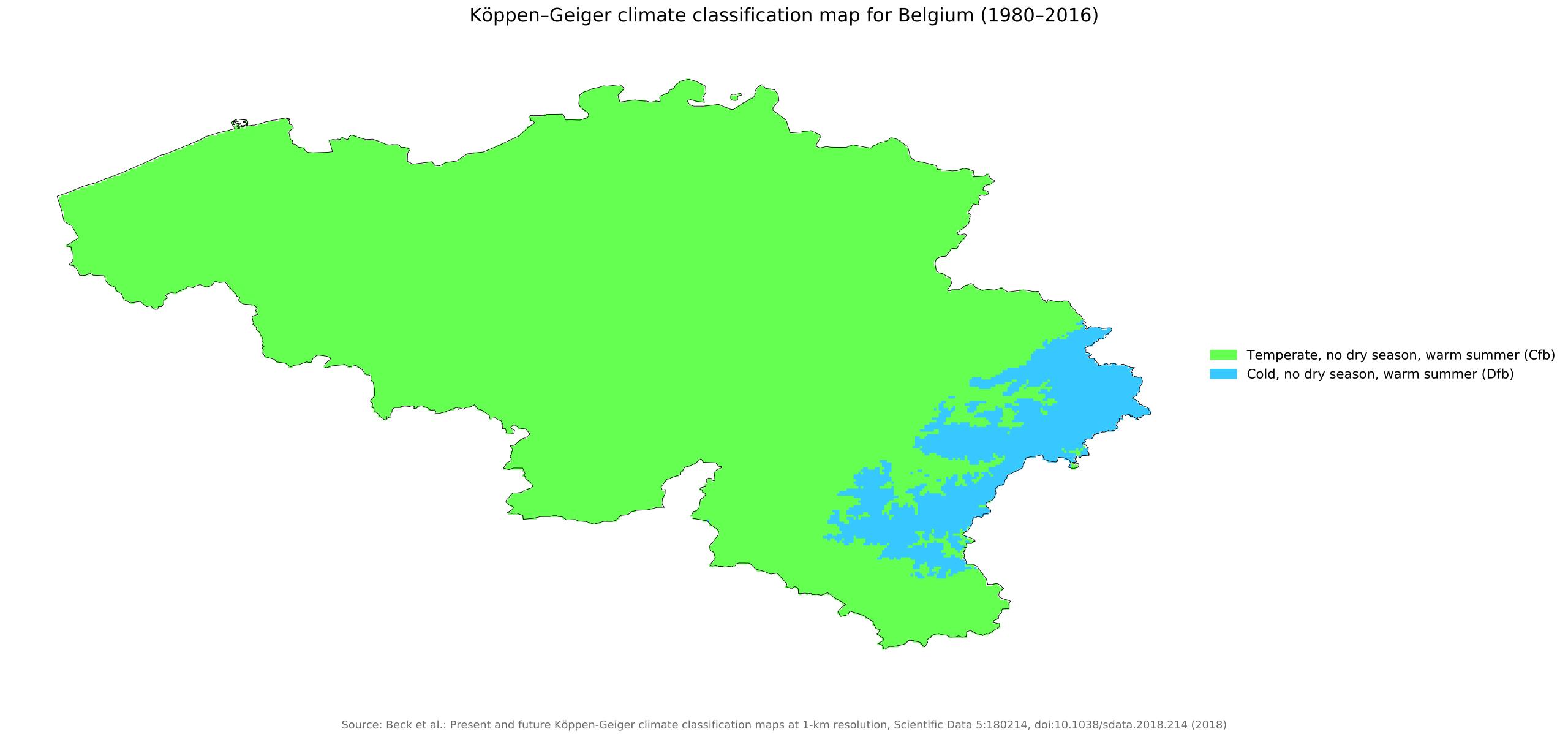
The Belgium climate map shows average temperature and climate zones of Belgium. This climate map of Belgium will allow you to know weather, average precipitation, average sunshine and different climates of Belgium in Western Europe. The Belgium climate map is downloadable in PDF, printable and free.
The climate of Belgium is cool and wet because it is influenced by the Atlantic Ocean, especially on the coast and the plain. In the south-eastern regions (Ardennes), which are located at higher altitudes as well as at a greater distance from the sea, the climate is more continental, and also more unstable in summer. Precipitation is frequent, but not particularly abundant. The coastal area is less rainy, and it is also slightly sunnier than the interior: precipitation amounts to 700 millimeters (27.5 inches) per year in Ostend, located on the coast, to 825 mm (32.5 in) in Brussels, a hundred kilometers (60 miles) away from the coast, and to 1,100 mm (43 in) in Spa, in the Ardennes as you can see in Belgium climate map. Sometimes, Belgium can be reached by hot air masses, which can raise the temperatures above 30 °C (86 °F). These hot spells are becoming more frequent due to global warming. In July 2019, the temperature reached 37 °C (98.5 °F) in Spa, 39 °C (102 °F) in Ostend and 40 °C (104 °F) in Brussels.
Winter is cold on the coast, but not freezing. The average temperature in February (which is, albeit slightly, the coldest month on the coast) is about 4 °C (39 °F). Sunshine is rare and the rains are frequent. Proceeding towards the interior, the temperature gradually decreases. The rains are frequent here as well. In the Ardennes, the winter is colder, both because of the altitude and because of the greater distance from the sea as its shown in Belgium climate map. In Bastogne, Spa and Saint-Hubert, approximately 500 meters (1,600 feet) above sea level, the average January temperature drops to about 0 °C (32 °F), and snow often falls instead of rain. Spring and autumn are cool and cloudy seasons. It can be still cold in March and in the first half of April, and sometimes even in early May, with highs around 10 °C (50 °F). Spring, however, is not as rainy as autumn, and it is the (relatively) driest season of the year. Autumn can be windy and gray, especially on the coast.
Apart from the average temperatures, in winter, the weather in Belgium varies depending on meteorological condition. The coldest days occur when the normal flow of Atlantic currents is arrested and is replaced by cold air masses from Eastern Europe: in these cases, the temperature drops below freezing (0 °C or 32 °F), and snow can fall throughout the country. During the coldest winters, the temperature can drop to around -15 °C (5 °F). On the contrary, when the westerlies get stronger, the temperature can become mild even in winter, above 10 °C (50 °F), but sometimes, there can be strong winds and even storm surges. Summer is pretty cool on the coast, with maximum temperatures reaching 21/22 °C (68/72 °F) in July and August as its mentioned in Belgium climate map. Cloudy and rainy days, brought by Atlantic fronts, can occur in Belgium even in this season. In inland areas, the weather in summer is slightly warmer: in Brussels, the daily average in July is about 18.5 °C (65.5 °F), with highs about 23.5 °C (74 °F), but here too, hot days are rare. The rains are more frequent because of the higher chance of afternoon thunderstorms.